Coastal Resiliency Planning
Odiorne Point State Park
In collaboration with the New Hampshire Department of Natural and Cultural Resources (DNCR) and other partners, the Rockingham County Conservation District (RCCD) is expanding its long-term habitat management efforts to include a focused evaluation of coastal resiliency at Odiorne Point State Park.

Planning Today, Protecting Tomorrow
Across the East Coast, salt marshes are under pressure from sea level rise. As water levels increase faster than marshes can grow vertically, they begin to erode or migrate inland to higher ground. This shift is already visible at the park, where: trail flooding is happening more often, shorelines and trails are eroding, and coastal habitats are becoming more vulnerable.
With funding from the New Hampshire Department of Environmental Services Coastal Program Coastal Resilient Grant, RCCD and partners continue to assess the resiliency of the existing trail system and explore strategic options for relocating trails inland to areas of higher elevation.

Planning Tools & Data Sources


To guide decisions, we’re using a combination of powerful tools and local data:
Sea Level Rise (SLR) Modeling
Marsh Migration Projections (SLAMM)
High-Resolution LiDAR Elevation Data
Park Visitor User Surveys
Natural Resource Surveys
These tools help us strike a balance between recreationl access and enviornemental stewardship as we adapt to a changing climate.

What is SLAMM?
The Sea Level Affecting Marshes Model (SLAMM) is a computer-based tool that helps predict how sea level rise may impact coastal wetlands like salt marshes and tidal flats. It simulates processes such as flooding, erosion, and habitat conversion to project how these areas could respond or migrate over time.
SLAMM Projections for 2050: Marsh Migration at Odiorne’s Little Harbor

2022 Existing Marsh

2050 Predicted Marsh Migration
Current Initiatives:
As we plan for long-term sustainability and climate resilience, our upcoming priorities include:
Trail Planning and Modifications:
Trails are one of the most important ways visitors experience the park — but they are also vulnerable to changing conditions. At Odiorne, coastal trails are already feeling the impacts of rising sea levels and stronger storm surges, with erosion and flooding becoming more common. To address these challenges, RCCD and partners are assessing the resiliency of the existing trail system and exploring strategic options to relocate trails inland to higher ground, ensuring safe and sustainable access for the future.
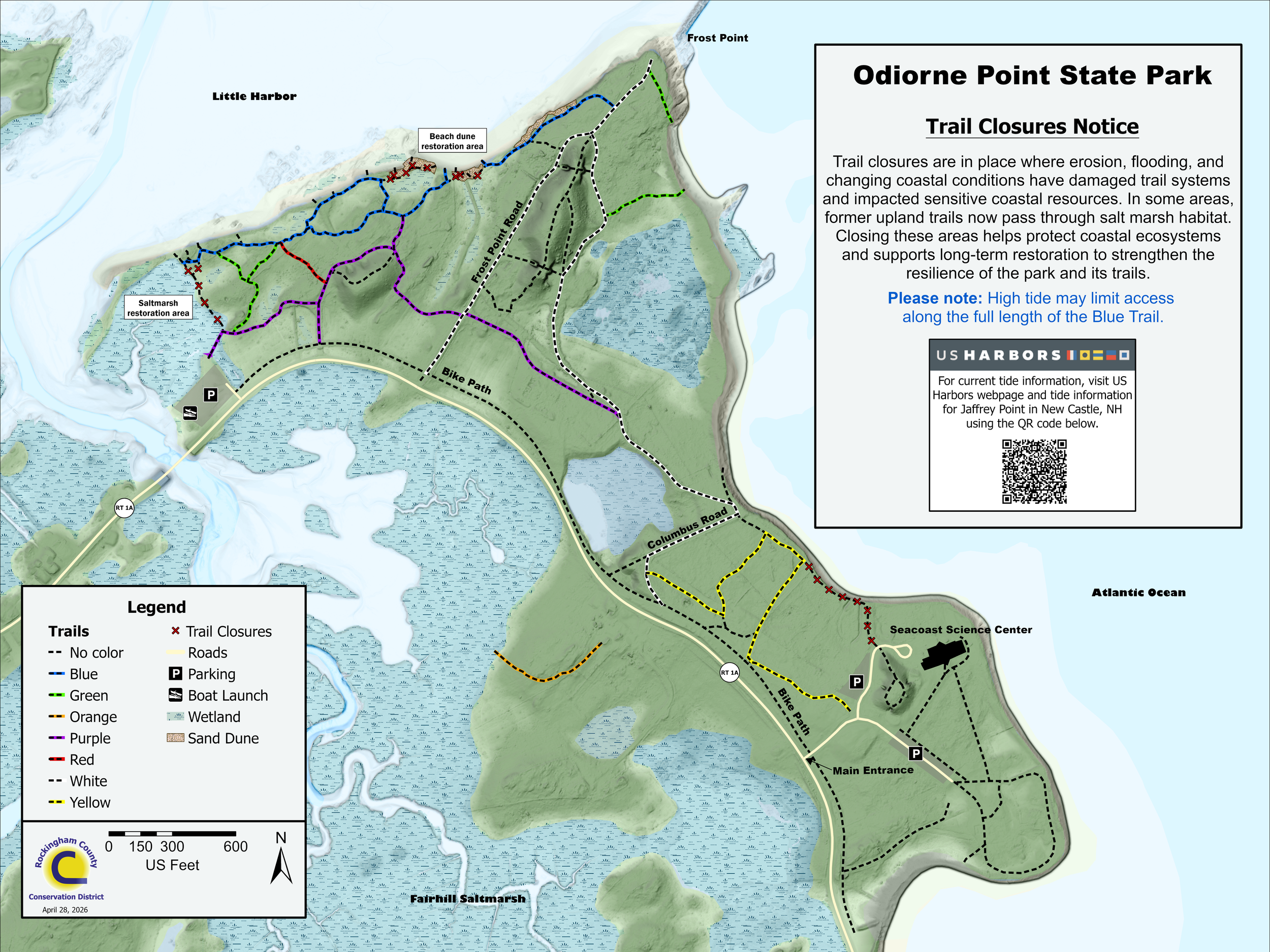
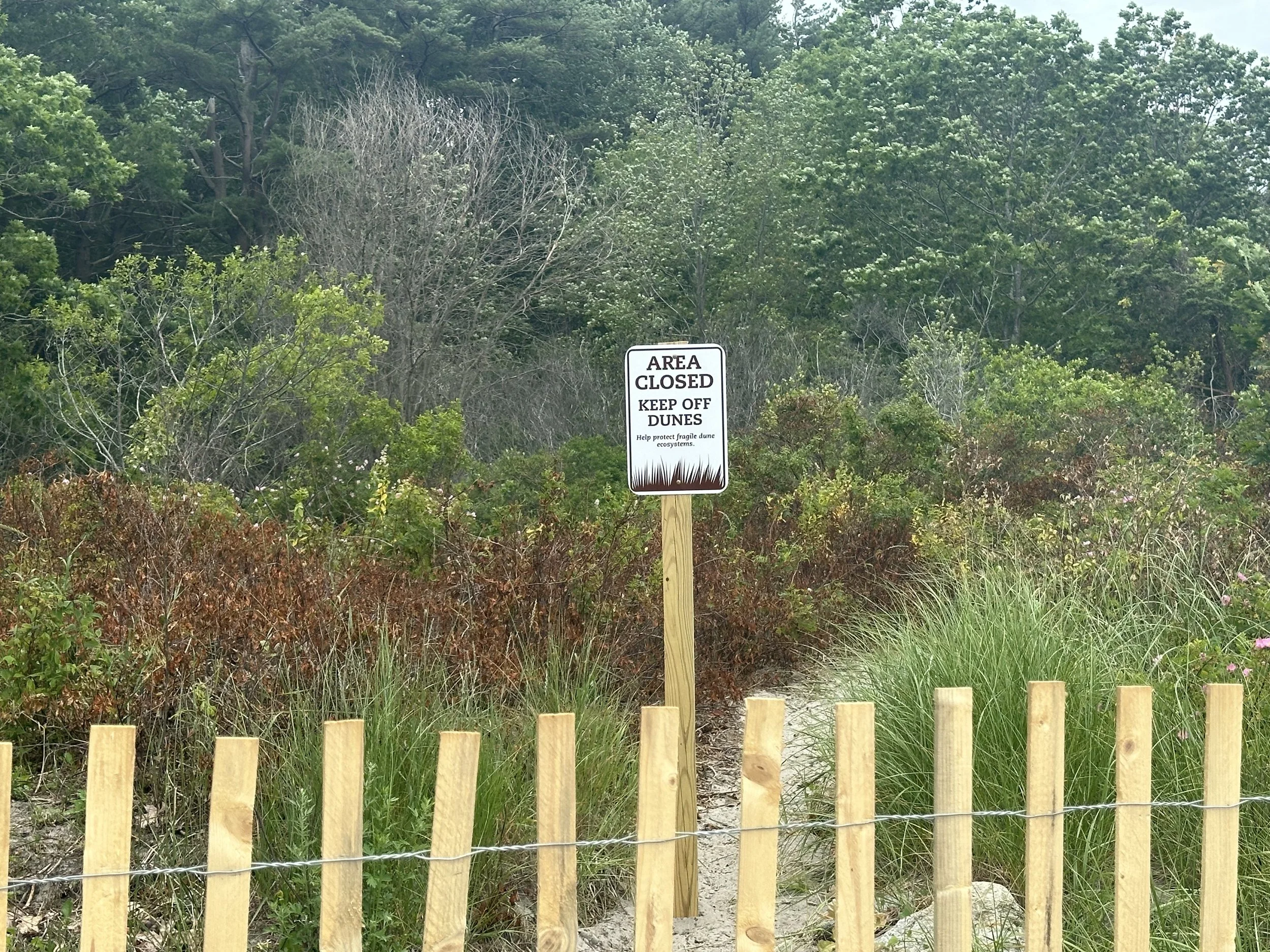
Upcoming Trail Closure Notice:
Beginning May 26th 2026, a portion of the trail nearest the boat launch at Odiorne Point will be permanently closed.
If you’ve visited this area recently, you may have noticed frequent flooding, muddy conditions, or sections of trail underwater. These changes are the result of sea level rise and marsh migration—a natural process where coastal salt marshes move inland over time.
To protect sensitive coastal habitat and improve visitor safety, this section of trail will be closed and access will be redirected to a newly developed upland route. The new path will maintain access to the beach and connections to the broader trail system.
Read our latest restoration update:
Marshes on the Move: Understanding the Upcoming Trail Closure at Odiorne Point State Park


Beach Dune Restoration:
Dune A
The Role of Dunes in Coastal Health:
Sand dunes are more than scenic coastal landmarks—they are dynamic ecosystems that serve essential ecological and protective functions. As natural barriers, they absorb the impact of storm surges, helping to minimize coastal flooding and erosion. Additionally, dunes act as reservoirs of sand, gradually replenishing beaches and supporting long-term shoreline stability.
In New Hampshire, dune ecosystems provide essential habitat for native wildlife, including the Semipalmated Sandpiper (Calidris pusilla), which utilizes the dunes as a stopover site during migration. These small shorebirds rely on coastal habitats to rest and refuel before continuing their long journey. Additionally, the state-endangered Least Tern (Sternula antillarum) and federally threatened piping plover (Charadrius melodus) depend on sandy beaches for nesting, and require quiet undisturbed areas to successfully raise their young. Dunes also support native plant species like Seaside Goldenrod (Solidago sempervirens), Beach Pea (Lathyrus japonicus), and American beach grass (Ammophila brevillgulata), which anchors the sand and promotes the growth and resilience of the dune system.

2022

2024
Threats to the Dunes:
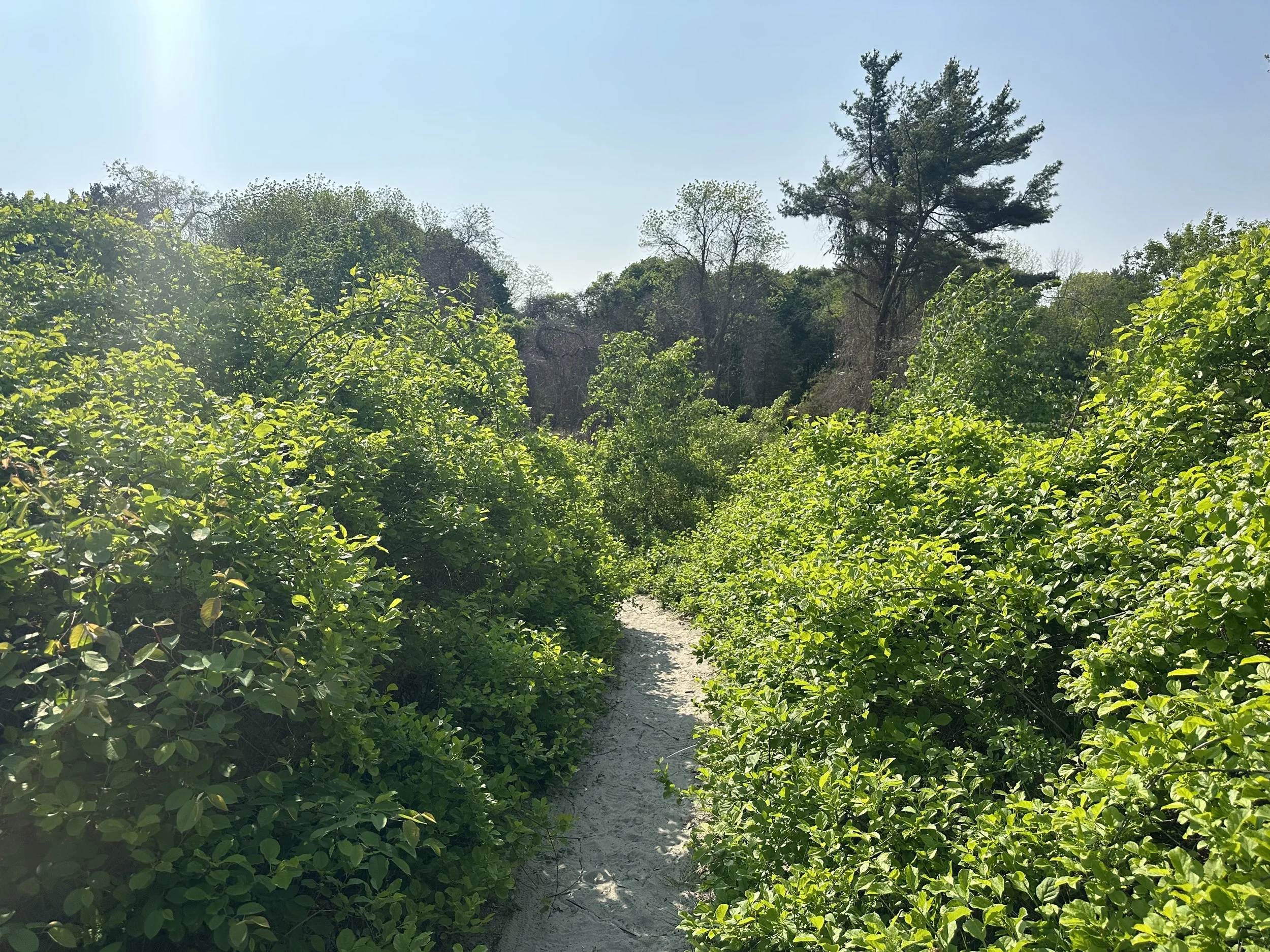
● Trail Use and Foot Traffic: Trails running directly through dunes compact the sand and crush native vegetation. Without plant roots to hold the sand in place, dunes quickly erode and lose their natural shape and strength. Even well-intentioned use of informal paths can cause long-term damage.
● Non-Native Vegetation: Non-native invasive plants, such as Oriental bittersweet (Celastrus orbiculatus) and Rugosa or Beach rose (Rosa rugosa), are a major threat to dune ecosystems. These species form dense colonies that outcompete native plants and hinder the natural movement of dunes. Their deep root and rhizome (stem) systems "armor" the dunes, preventing the natural migration of sand.
● Climate Change and Sea Level Rise: As sea levels rise and storms intensify, dunes face more frequent and severe erosion. Healthy, mobile dunes can naturally recover after these events—but degraded dunes struggle to rebuild without assistance.
Restoring Balance:
The trail closures are a vital step in allowing our coastal dune systems to recover and thrive. Years of heavy foot traffic and the spread of invasive plants have taken a toll on these fragile ecosystems and without intervention they will likely be lost.
As part of the restoration, teams will remove invasive species and plant native dune species like American beachgrass. These plants play a crucial role in holding the sand in place and helping dunes rebuild over time. Reducing disturbance allows the ecosystem to regain its natural shape and function—restoring not just the beauty of the landscape, but also its ability to protect the shoreline and support wildlife.
Restoration Progress Updates:
Dune Trail Closures: As part of an ongoing dune restoration project, two segments of trail through the dunes along the Little Harbor shoreline at Odiorne Point State Park were closed in June 2025. Access along the coastal trail from the boat launch to Frost Point now depends on the tide:
Low Tide: The trail will remain accessible, with the route shifting onto the beach.
High Tide: Visitors will need to take an inland trail to navigate around the closure.
To clearly indicate these changes, fencing and signage were installed to mark the closed areas. Additional signage was also placed throughout the area to help visitors find the appropriate trails based on tide conditions. To support this transition, two new trails were introduced, providing safe inland and beach access while preserving the dunes.
A map highlighting the trail closures is available to the public—download your copy below!
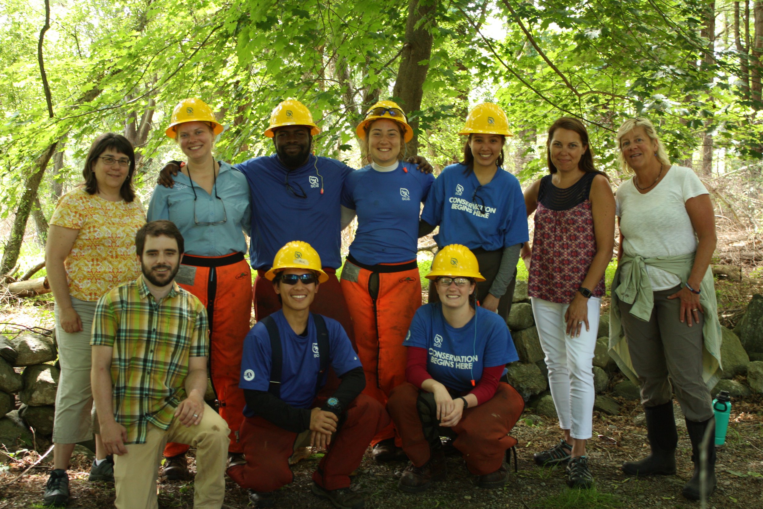
Dune Restoration Progress: Over the past two weeks, the Student Conservation Association (SCA) joined forces with RCCD and DNCR to tackle a variety of projects across the Park. One major focus was assisting in the restoration of two beach dunes along the Little Harbor shoreline. In just two days, the team planted over 2,000 stems of American beachgrass, grown at the Common Garden in Hampton. This grass is essential for keeping the dunes in place and protecting them from erosion caused by wind and waves.
The crew also took on the tough job of removing dead invasive plants, including tangled Oriental bittersweet, from the dunes. Clearing this vegetation prepares the area for future planting efforts, which are planned for fall 2026.
Check out the progress below!

Dune B
Dune B inundated with invasive Oriental bittersweet prior to control efforts (5/22/2023).

Dune B after initial invasive plant control efforts (9/5/2025).

Dune B after invasive debris removal (9/10/2025).
Dune closure signage (6/26/2025)
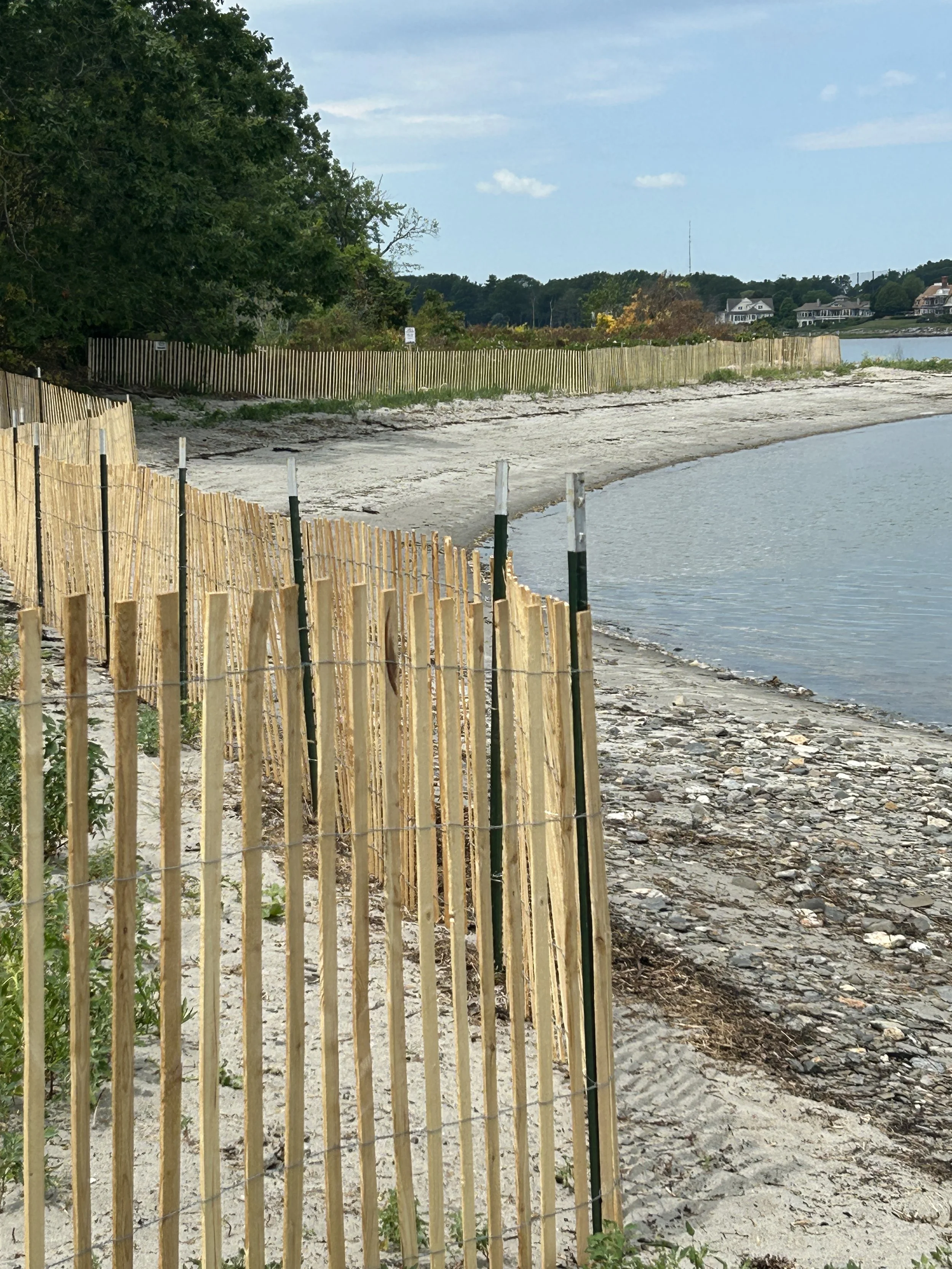
View of sand fencing surrounding Dune A and Dune B (6/26/2025).
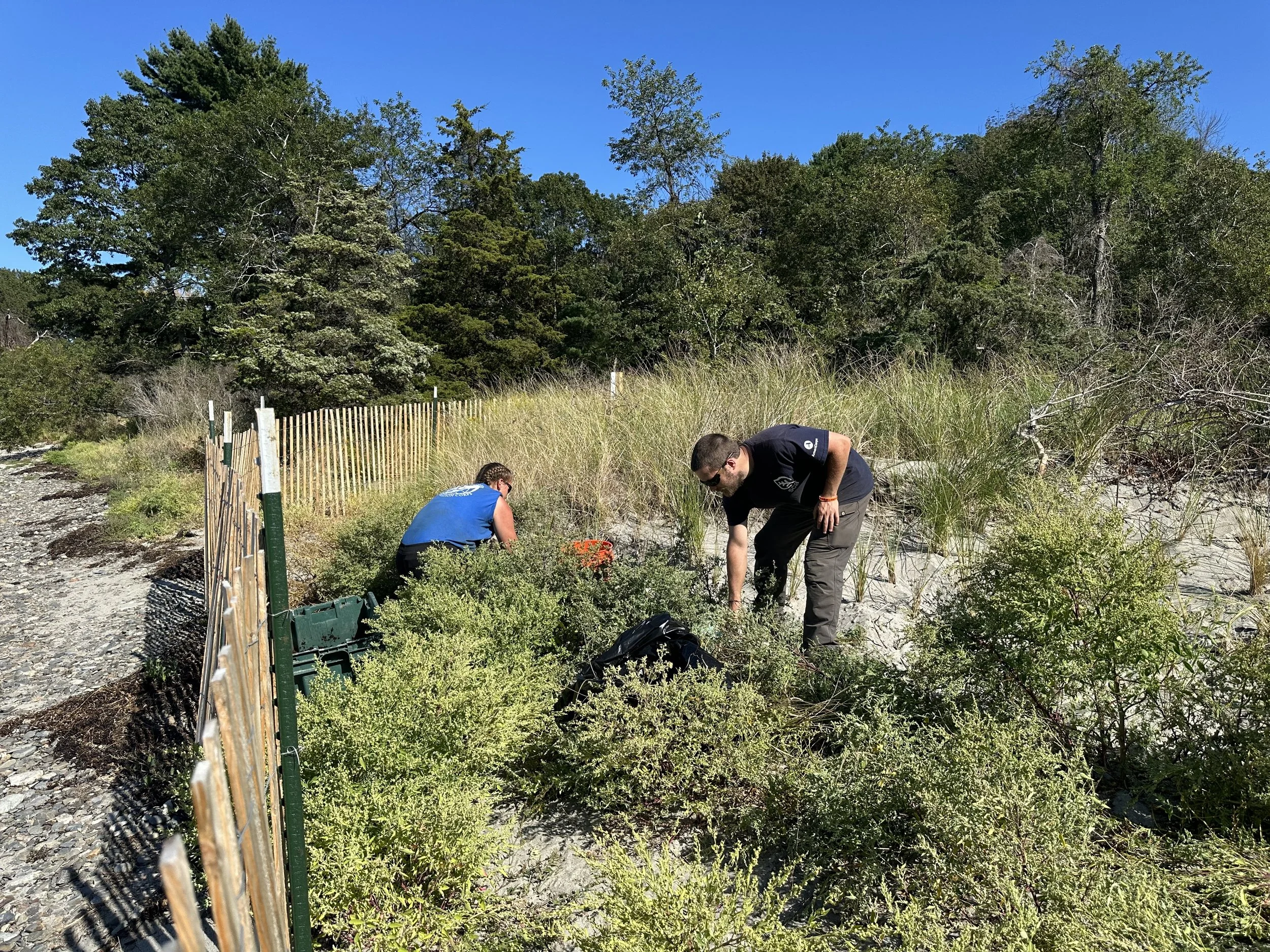
SCA planting American beach grass (9/5/2025).

SCA planting American beach grass

American beach grass (9/5/2025)

American beach grass planted within the foredune (9/5/2025).


Project Partners


Check Out Other Projects at Odiorne